Instant, Eurocode-aligned terrain category — right where you’re standing.
Terrain category is one of those parameters everyone agrees is important — yet in practice, it’s often inconsistent, subjective, or based on assumptions rather than data. For temporary structures, where site conditions change from project to project, that inconsistency becomes a real engineering risk.
eventTerrain was built to eliminate that gap by turning on‑site geodata into a consistent, Eurocode-aligned exposure assessmentThis post dives into the technical side of how it works — and why it matters.
The Problem: Terrain Category Is Easy to Misjudge
Terrain category is deceptively simple on paper. But in the field, engineers face challenges like:
- rapidly changing surroundings
- mixed land-use zones
- unclear upwind fetch
- elevation and topographic effects that are hard to quantify
- inconsistent interpretations between teams
The result? Two engineers can stand on the same site and reach different conclusions — and both believe they’re right.
eventTerrain tackles this by grounding the assessment in geospatial data, elevation models, and Eurocode logic, all processed instantly on a mobile device.
How eventTerrain Performs the Assessment
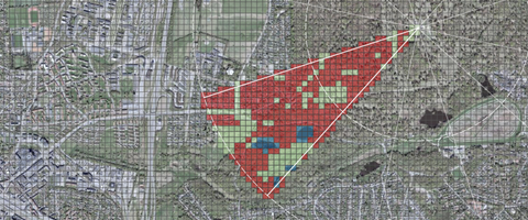
1. Geo-located sampling of the actual site
Instead of relying on regional assumptions, the system evaluates the precise location where the user stands. This includes:
- land-cover characteristics
- roughness transitions
- upwind exposure
- local elevation and slope
2. Eurocode‑aware logic
The assessment applies Eurocode‑compliant calculations and the relevant National Annex parameters for the country you’re in.This ensures the output aligns with the same rules used in formal engineering documentation.
3. Topographic amplification
Elevation effects and topographic amplification are automatically included in the analysis, based on the surrounding terrain geometry.
4. Transparent, independent data sources
All inputs come from open datasets from national agencies and EU sources — no proprietary black-box models.
Why Mobile-First Matters
Temporary-structure setup is often done under time pressure:
- site visits squeezed between meetings
- build-day decisions that can’t wait
- last-minute changes to layout or anchoring
- clients expecting instant answers
- opens instantly in the mobile browser
- requires no installation or login
- doesn’t access unnecessary personal data
It’s a technical tool built for operational reality.
A Consistent Basis for Ballast, Anchoring, and Review
Once the terrain category is determined, the result becomes a shared reference point for:
- ballast and anchoring assumptions
- layout decisions
- technical reviews
- quote-stage planning
This is explicitly how the tool is intended to be used: as a consistent, defensible basis for exposure assessment across teams and repeated sites.
Not a Replacement for Engineering Judgment - a Reinforcement of It
Results should always be reviewed as part of a professional engineering process.
eventTerrain doesn’t replace engineering responsibility — it strengthens it by removing avoidable uncertainty.
Why This Matters for the Future of Temporary Structures
As temporary structures become larger, more complex, and more regulated, the industry needs tools that:
- reduce subjective interpretation
- improve documentation quality
- support defensible decisions
- scale across teams and regions
Automated, location-based terrain assessment is a natural evolution of that need.
eventTerrain brings that capability directly into the hands of the people who need it most — engineers, suppliers, and operators working on real sites, in real time.
Get started - go to: https://ndp.dk/event/info